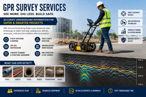
A GPR Survey (Ground Penetrating Radar Survey) is one of the most advanced non-destructive investigation methods used to detect underground utilities, buried structures, voids, pipelines, cables, and subsurface anomalies. Today, industries such as construction, infrastructure, mining, archaeology, road inspection, and utility mapping rely heavily on GPR scanning services for accurate underground detection without excavation.
With increasing urban development and smart city projects, the demand for professional ground penetrating radar survey services is growing rapidly across India and globally. GPR technology helps engineers, contractors, and project managers avoid costly underground damages while improving safety and project efficiency.
What is Ground Penetrating Radar (GPR)?
Ground Penetrating Radar is a geophysical method that uses high-frequency electromagnetic waves to scan beneath the ground surface. The radar system transmits signals into the ground, and when these waves encounter different materials such as concrete, metal, soil layers, or utilities, they reflect back to the receiver.
The collected data is processed to identify:
- Underground utilities
- RCC reinforcement
- Buried pipelines
- Voids and cavities
- Underground tanks
- Cables and conduits
- Concrete thickness
- Soil conditions
- Structural defects
This technology is widely known as:
- GPR scanning
- Underground utility survey
- Radar survey
- Concrete scanning
- Subsurface utility mapping
Importance of GPR Survey in Modern Construction
Modern infrastructure projects require precise underground information before excavation or drilling begins. A professional GPR survey company helps prevent accidental utility strikes and project delays.
Major Benefits of GPR Survey
- Non-Destructive Testing: GPR scanning does not damage the surface or underground structures.
- Accurate Utility Detection: It identifies underground pipelines, electrical cables, water lines, and telecom ducts with high precision.
- Improved Safety: Underground utility mapping minimizes the risk of accidents during excavation.
- Cost Savings: Detecting buried objects before construction avoids repair costs and project delays.
- Fast Data Collection: Large areas can be scanned quickly using advanced radar systems.
- Better Project Planning: Engineers receive detailed underground information for informed decision-making.
Applications of GPR Survey Services
Underground Utility Detection
One of the most common applications of a ground penetrating radar survey is locating underground utilities. Contractors use GPR utility surveys before excavation work to identify:
- Water pipelines
- Gas pipelines
- Electrical cables
- Fiber optic cables
- Drainage systems
- Sewer lines
Concrete Scanning Services
GPR concrete scanning is used in buildings, bridges, and industrial structures to locate:
- Rebar
- Post-tension cables
- Conduits
- Voids in concrete
- Concrete thickness
This prevents accidental damage during drilling and cutting operations.
Road and Highway Investigation
GPR road surveys help analyze:
- Pavement thickness
- Road layer conditions
- Subsurface defects
- Moisture intrusion
Transportation departments widely use this method for highway maintenance and rehabilitation.
Archaeological Investigations
Archaeologists use GPR scanning to locate buried historical structures and artifacts without excavation.
Geological and Mining Surveys
Mining industries use GPR technology for:
- Rock profiling
- Void detection
- Tunnel inspection
- Fracture mapping
GPR Survey Process
Step 1: Site Assessment: Engineers evaluate the project area and survey requirements.
Step 2: Data Collection: The radar antenna is moved across the surface while transmitting electromagnetic waves.
Step 3: Signal Reflection: Different underground materials reflect signals back to the receiver.
Step 4: Data Processing: Software converts reflections into readable underground profiles.
Step 5: Report Generation: Detailed survey reports and utility maps are prepared.
Types of GPR Surveys
- Utility Mapping Survey: Used for locating underground services and pipelines.
- Concrete GPR Scanning: Used in structural engineering and construction projects.
- Floor Scanning Survey: Helps detect embedded conduits and reinforcement in slabs.
- Geological GPR Survey: Used for subsurface geological investigations.
- Void Detection Survey: Identifies underground cavities and sinkholes.
- Rebar Scanning: Detects reinforcement bars within concrete structures.
Industries Using GPR Survey Services
Many industries depend on professional GPR scanning companies.
- Construction Industry: Builders use underground utility surveys before excavation and foundation work.
- Infrastructure Projects: Metro rail, airports, highways, and smart city projects require detailed subsurface mapping.
- Oil and Gas Industry: GPR helps identify buried pipelines and underground assets.
- Telecommunications: Telecom companies use utility mapping for cable installations.
- Municipal Corporations: Authorities use GPR inspection for drainage and water management systems.
- Railways: Rail infrastructure projects require subsurface investigations for safe construction.
Advantages of Hiring a Professional GPR Survey Company
Choosing an experienced GPR survey company ensures:
- Accurate underground mapping
- High-quality radar equipment
- Skilled survey professionals
- Reliable data interpretation
- Detailed CAD and GIS reports
- Faster project execution
Professional survey teams also integrate GPR data with:
- Total Station Survey
- DGPS Survey
- GIS Mapping
- Drone Survey
- LiDAR Survey
This provides comprehensive geospatial solutions.
GPR Survey Equipment and Technology
Modern GPR systems use advanced radar antennas with different frequencies depending on the survey depth and resolution required.
- High Frequency Antennas: Used for shallow investigations and concrete scanning.
- Low Frequency Antennas: Used for deeper underground investigations.
- 3D GPR Imaging: Advanced systems generate 3D underground utility maps for complex projects.
- GPS Integrated GPR: Combines radar data with precise geographic coordinates.
Factors Affecting GPR Survey Accuracy
Several conditions influence radar performance:
- Soil moisture
- Clay content
- Ground conductivity
- Survey depth
- Surface conditions
- Type of underground material
Why GPR Survey is Essential Before Excavation
Excavation without underground investigation can lead to:
- Utility damage
- Electrical hazards
- Project delays
- Financial losses
- Legal complications
A professional underground utility detection survey minimizes these risks significantly.
Future of Ground Penetrating Radar Survey
The future of GPR technology is evolving rapidly with:
- AI-based interpretation
- 3D subsurface visualization
- Cloud-based data processing
- Integration with BIM
- Real-time underground mapping
Choosing the Right GPR Survey Service Provider
When selecting a GPR survey agency, consider:
- Industry experience
- Equipment quality
- Technical expertise
- Previous project portfolio
- Reporting capabilities
- Turnaround time
A GPR Survey or Ground probing radar survey is an essential solution for safe and efficient underground investigation. From underground utility mapping and concrete scanning to geological studies and infrastructure inspections, ground penetrating radar technology plays a critical role in modern engineering projects.
As urban development continues to grow, the demand for accurate ground penetrating radar survey services will increase significantly. Investing in professional GPR scanning helps organizations improve safety, reduce risks, and optimize project execution.
Whether for construction, infrastructure, industrial, or utility mapping applications, GPR technology provides fast, reliable, and non-destructive subsurface investigation solutions.