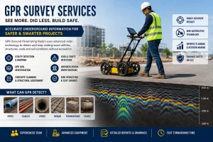
Construction projects often face unexpected challenges below the ground surface. Buried utilities, abandoned foundations, underground tanks, voids, and unknown structures can create delays, increase costs, and pose safety risks. This is where a professional GPR Survey becomes an essential part of project planning.
Ground Penetrating Radar (GPR) is a non-destructive technology that helps engineers, contractors, utility owners, and developers understand subsurface conditions before excavation begins. Whether you are planning a highway, industrial facility, commercial development, railway corridor, or utility installation, investing in reliable GPR Survey Services can help prevent costly surprises and improve project outcomes.
Why Project Need in GPR Survey Services
Many project owners already understand the basics of GPR technology. The real question is how the survey can reduce risk and save money.
A professional survey helps identify:
- Underground electrical cables
- Water supply pipelines
- Sewer networks
- Gas pipelines
- Fiber optic cables
- Buried concrete structures
- Underground storage tanks
- Voids and cavities
- Unknown foundations
- Subsurface obstructions
GPR Utility Survey for Safe Excavation
One of the most common applications of GPR is utility mapping. A detailed GPR Utility Survey enables contractors and engineers to locate buried services before excavation, trenching, piling, or horizontal directional drilling.
Utility damage can result in:
- Expensive repairs
- Construction delays
- Safety hazards
- Service interruptions
- Regulatory penalties
How Underground Radar Surveys Support Infrastructure Projects
Large infrastructure developments involve significant underground uncertainty. An Underground Radar Survey provides valuable subsurface information for:
- Highways and expressways
- Railways and metro systems
- Airports
- Industrial plants
- Smart city projects
- Commercial developments
- Residential townships
- Utility corridors
GPR Soil Investigation for Better Site Understanding
Traditional geotechnical investigations provide information at borehole locations, but they may not reveal variations between those points. A GPR Soil Investigation can complement borehole data by providing continuous subsurface information across the site.
This approach can help identify:
- Soil layer variations
- Buried debris
- Voids
- Rock interfaces
- Subsurface anomalies
- Hidden obstructions
Radar Survey Applications in Existing Structures
A Radar Survey is not limited to open ground investigations. It is also widely used for structural assessments and concrete scanning.
Applications include:
- Rebar detection
- Post-tension cable location
- Concrete thickness measurement
- Slab investigations
- Structural rehabilitation projects
Ground Penetrating Radar for Archaeological Investigations
Beyond engineering and construction, Ground Penetrating Radar for Archaeological Investigations has become a valuable tool for heritage and research projects.
Archaeologists use GPR to identify:
- Ancient foundations
- Buried walls
- Historical roads
- Tombs and burial sites
- Cultural heritage remains
Ground Penetrating Radar Survey Cost: What Determines Pricing?
Many clients ask about the Ground Penetrating Radar Survey Cost during project planning. Survey pricing varies based on several factors.
Survey Area: Larger sites require more fieldwork and data processing.
Investigation Depth: The required depth of penetration can influence equipment selection and survey methodology.
Site Complexity: Urban environments with dense utilities often require more detailed investigations than open land.
Project Objectives: The requirements for utility mapping, structural assessment, archaeological studies, and geotechnical investigations can differ significantly.
Deliverables
The final scope may include:
- Utility maps
- CAD drawings
- GIS integration
- Engineering reports
- Subsurface profiles
Selecting the Right GPR Survey Companies
Choosing experienced GPR Survey Companies is critical for obtaining reliable results.
Key factors to evaluate include:
- Technical Expertise: Survey teams should have experience across infrastructure, industrial, commercial, and utility projects.
- Advanced Equipment: Modern radar systems provide improved data quality and better detection capabilities.
- Data Interpretation Skills: Collecting radar data is only the first step. Accurate interpretation requires trained specialists who understand subsurface conditions.
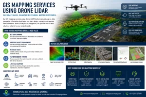
Integrated Survey Solutions
Many clients benefit from providers who offer:
- Utility mapping
- Topographic surveys
- GIS services
- Drone surveys
- Geotechnical investigations
- Engineering consultancy
Searching for GPR Survey Near Me
When organizations search online for a GPR Survey Near Me, they are often looking for a fast and reliable solution to support ongoing projects. However, technical capability is usually more important than proximity.
An ideal survey provider should offer:
- Experienced engineers
- Modern GPR equipment
- Utility mapping expertise
- Professional reporting
- Fast turnaround times
- Nationwide project support
Why a Georadar Survey is a Valuable Investment
Every excavation carries some level of uncertainty. A professional Georadar Survey helps reduce that uncertainty by providing accurate subsurface information before work begins.
For project owners, contractors, consultants, and infrastructure developers, the benefits include:
- Reduced excavation risk
- Improved safety
- Better planning accuracy
- Fewer project delays
- Lower construction costs
- Protection of existing utilities
The information obtained through a Ground Probing Radar Survey often proves far more valuable than the cost of addressing unexpected underground issues during construction. As infrastructure and construction projects become more complex, understanding underground conditions before excavation is essential. Whether the requirement involves utility detection, soil investigation, structural assessment, or archaeological studies, a professional survey georadar solution provides valuable insights that support informed decision-making. By investing in high-quality GPR Survey Services, project teams can reduce uncertainty, improve safety, protect underground assets, and keep projects on schedule. The result is better planning, lower risk, and greater confidence throughout the project lifecycle.