Water is one of the most valuable natural resources, and its proper management is essential for infrastructure development, environmental conservation, agriculture, mining, and urban planning. A Hydrological Survey is a scientific process used to study the movement, distribution, quality, and availability of water in a specific area. These surveys provide critical data that helps engineers, planners, government agencies, and industries make informed decisions regarding water resource management.
Whether it is the construction of a dam, bridge, highway, industrial facility, or urban development project, understanding water behavior is crucial for ensuring safety, sustainability, and long-term success.
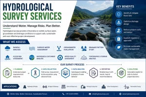
What is a Hydrological Survey?
A Hydrological Survey is a systematic assessment of surface water and groundwater resources within a defined region. The survey collects and analyses data related to Rainfall patterns, River and stream flow, Water levels, Watershed characteristics, Groundwater availability, Flood risks, Water quality, Drainage systems
Why is a Hydrological Survey Important?
Hydrological surveys play a vital role in various sectors because water-related challenges can significantly affect infrastructure and environmental stability.
- Flood Risk Assessment: Hydrological studies help identify flood-prone areas and estimate flood frequencies. This information enables planners to design effective flood control measures and reduce risks to people and property.
- Infrastructure Planning: Before constructing bridges, roads, railways, dams, pipelines, or buildings, engineers need accurate water flow data to ensure structural safety and longevity.
- Water Resource Management: Hydrological surveys help determine available water resources and support sustainable water allocation for domestic, agricultural, and industrial use.
- Environmental Protection: Understanding hydrological conditions helps minimize environmental impacts and supports ecosystem conservation.
- Groundwater Evaluation: Hydrological investigations assist in identifying groundwater recharge zones and assessing groundwater availability.
Applications of Hydrological Surveys
Hydrological surveys are widely used across multiple industries and sectors.
- Infrastructure Development: Highways, Railways, Bridges, Airports, Smart cities, Industrial parks
- Water Resource Projects: Dams, Reservoirs, Irrigation systems, Canal networks, Water supply schemes
- Mining and Energy Projects: Mine drainage planning, Tailings management, Hydropower projects, Solar and wind farms
- Urban Development: Stormwater management, Drainage design, Flood mitigation planning, Smart city infrastructure
- Environmental Studies: Wetland assessment, Watershed management, River restoration projects, Environmental impact assessments
Types of Hydrological Surveys
- Surface Water Survey: Focuses on rivers, lakes, streams, reservoirs, and drainage systems. It evaluates flow rates, water levels, and seasonal variations.
- Groundwater Survey: Examines underground water resources, aquifer characteristics, recharge rates, and groundwater potential.
- Watershed Survey: Studies an entire drainage basin to understand runoff patterns, erosion risks, and water distribution.
- Floodplain Survey: Analyses flood-prone areas and helps determine safe development zones.
- Water Quality Survey: Evaluates physical, chemical, and biological parameters to assess water suitability for various uses.
Hydrological Survey Methodology
A professional hydrological survey typically follows several stages.
- Preliminary Study: Experts review available maps, satellite imagery, historical rainfall records, river flow data, and previous studies.
- Field Investigation: Survey teams collect on-site data using advanced instruments and monitoring equipment.
- Data Collection
Important information gathered includes:
- Rainfall measurements
- Stream flow data
- Water level observations
- Catchment characteristics
- Soil conditions
- Groundwater information
- Survey and Mapping
Modern technologies are used to create accurate terrain and watershed maps.
- Drone Survey
- LiDAR Survey
- GIS Mapping
- GPS Survey
- Remote Sensing
- Total Station Survey
- Hydrological Modeling: Specialized software is used to simulate water movement, flood behavior, runoff patterns, and drainage performance.
- Analysis and Reporting
Survey findings are compiled into detailed reports containing:
- Hydrological calculations
- Flood analysis
- Water balance studies
- Risk assessments
- Engineering recommendations
Technologies Used in Modern Hydrological Surveys
- Drone Survey: Drones provide high-resolution aerial data and rapid site coverage, making them ideal for watershed and floodplain mapping.
- LiDAR Survey: LiDAR technology generates highly accurate elevation models, helping identify drainage paths and flood-prone areas.
- GIS Mapping: Geographic Information Systems allow hydrological data to be integrated, analyzed, and visualized efficiently.
- Remote Sensing: Satellite imagery helps monitor large watersheds and track environmental changes over time.
- GPS and GNSS Survey: These systems provide precise positioning data for hydrological monitoring and mapping activities.
Key Data Collected During Hydrological Surveys
A comprehensive hydrological survey typically includes:
- Rainfall records
- River discharge data
- Water level measurements
- Catchment area information
- Soil infiltration rates
- Evaporation data
- Groundwater levels
- Land use characteristics
- Drainage patterns
- Flood history records
Industries That Require Hydrological Surveys
Many industries rely on hydrological data before commencing projects, include: Construction, Infrastructure Development, Mining, Agriculture, Water Utilities, Renewable Energy, Environmental Consulting, Government Agencies, Urban Planning Authorities
Hydrological Survey Service:
When selecting a hydrological survey provider, consider:
- Industry experience
- Advanced survey equipment
- GIS and modeling capabilities
- Qualified hydrologists and surveyors
- Compliance with national standards
- Detailed reporting and analysis
A Hydrological Survey is an essential step in understanding water resources, flood risks, drainage systems, and environmental conditions. Accurate hydrological information supports safer infrastructure development, sustainable water management, and effective environmental planning.
By utilizing modern technologies such as Drone Survey, LiDAR, GIS Mapping, GPS, and Remote Sensing, professional hydrological survey services deliver precise and reliable data for projects of all sizes. Whether planning a bridge, highway, mining operation, irrigation network, or urban development project, investing in a comprehensive hydrological survey helps ensure long-term success, regulatory compliance, and environmental sustainability.
Frequently Asked Questions (FAQs)
- What is a Hydrological Survey?
Ans: A hydrological survey evaluates rainfall, surface water, groundwater, and drainage conditions to understand water behavior within a project area. It provides essential data for planning safe and sustainable developments.
- Why is a Hydrological Survey important for construction projects?
Ans: It helps identify flood risks, drainage challenges, and water availability issues before construction begins. This reduces project risks, delays, and unexpected costs.
- Which projects require a Hydrological Survey?
Ans: Hydrological surveys are commonly required for highways, bridges, railways, mining projects, dams, industrial facilities, and urban developments. They support informed design and regulatory compliance.
- How does a Hydrological Survey help in flood risk assessment?
Ans: The survey analyses rainfall patterns, runoff, watershed characteristics, and historical flood data to predict potential flooding. This information helps engineers design effective flood protection measures.
- What is included in a Hydrological Survey report?
Ans: A report typically includes rainfall analysis, drainage assessment, flood studies, groundwater evaluation, watershed analysis, and engineering recommendations. These findings support project planning and decision-making.