A bathymetric survey is the process of measuring and mapping the underwater depth and topography of water bodies such as reservoirs, lakes, dams, rivers, ponds, and canals. The survey provides detailed information about the submerged landscape, sediment accumulation, storage capacity, and underwater features that cannot be identified through conventional land surveying methods.
Why Bathymetric Surveys Are Important
Water bodies are crucial for irrigation, drinking water supply, industrial use, and flood management. Over time, reservoirs and lakes experience sediment deposition, reducing their storage capacity and operational efficiency. Accurate underwater mapping helps authorities, engineers, and project developers understand the actual condition of these water bodies.
Bathymetric surveys are widely used for reservoir management, desilting projects, dam safety assessments, irrigation modernization, flood mitigation studies, and infrastructure planning. The data generated enables stakeholders to make informed decisions while reducing project risks and costs.
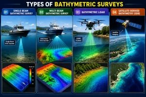
Types of Bathymetric Surveys
- Single Beam Bathymetric Survey (SBES)
Uses a Single Beam Echo Sounder to measure water depth directly beneath the survey vessel. It is a cost-effective solution for reservoirs, lakes, rivers, and canals where moderate survey detail is required.
- Multi Beam Bathymetric Survey (MBES)
Uses a Multi Beam Echo Sounder that emits multiple sonar beams simultaneously, collecting thousands of depth measurements per second. It produces highly accurate 3D underwater terrain models and is ideal for large reservoirs, dams, ports, and marine infrastructure projects.
- Bathymetric LiDAR Survey
Employs airborne laser technology to measure both land and shallow underwater terrain. Bathymetric LiDAR is particularly useful for coastal areas, rivers, reservoirs, floodplains, and large water bodies where rapid data collection is required.
- Satellite-Derived Bathymetry (SDB)
Utilizes high-resolution satellite imagery and advanced algorithms to estimate water depths in clear and shallow water environments. SDB is suitable for preliminary studies, coastal mapping, environmental monitoring, and large-area assessments where traditional survey methods may be impractical or costly.
Key Applications of Bathymetric Surveys
- Reservoir Capacity Assessment: Reservoirs gradually lose storage capacity due to silt accumulation. A bathymetric survey accurately determines the current water holding capacity and identifies areas requiring desilting.
- Dam Safety and Monitoring: Dam authorities require periodic underwater inspections to monitor sediment buildup, structural conditions, and changes in reservoir morphology.
- Lake Restoration Projects: Urban lakes often face encroachment, pollution, and sedimentation. Bathymetric mapping provides essential data for restoration and rejuvenation initiatives.
- Irrigation Canal and River Studies: Accurate depth measurements support hydraulic modeling, irrigation planning, and water flow analysis.
- Water Supply Infrastructure Projects: Municipal authorities and industrial organizations use bathymetric data for intake structures, pipeline planning, and water resource management.
- Mining and Industrial Water Bodies: Quarries, mining pits, and industrial reservoirs require underwater surveys for volume calculations, safety assessments, and environmental monitoring.
Technology Used in Modern Bathymetric Surveys
Modern bathymetric surveys utilize advanced hydrographic equipment to achieve high accuracy.
- Single Beam Echo Sounder: A Single Beam Echo Sounder measures water depth directly beneath the survey vessel. It is commonly used for lakes, reservoirs, and smaller water bodies.
- Multi Beam Echo Sounder: For large-scale projects, Multi Beam Echo Sounders collect thousands of depth measurements simultaneously, creating highly detailed underwater terrain models.
- RTK GPS Integration: Real-Time Kinematic GPS ensures precise positioning of every depth measurement, improving overall survey accuracy.
- Drone-Based Bathymetric Survey: In selected shallow-water environments, drone technology can assist in data collection, providing rapid and efficient survey coverage.
Survey deliverables typically include:
- Detailed bathymetric maps
- Underwater contour maps
- Digital Terrain Models (DTM)
- Reservoir capacity calculations
- Sedimentation analysis reports
- Volume computation reports
- GIS-compatible survey datasets
- Cross-sections and longitudinal profiles
Challenges in Bathymetric Survey Projects
Conducting underwater surveys involves several technical challenges. Dense aquatic vegetation, fluctuating water levels, floating debris, and accessibility constraints can affect survey operations. Data accuracy also depends on proper calibration of hydrographic equipment and precise positioning systems. Experienced survey teams use advanced methodologies and quality control procedures to overcome these challenges and deliver reliable results.
Benefits of Professional Bathymetric Survey Services
Accurate bathymetric data provides numerous advantages for project owners and government agencies. It helps optimize dredging activities, improve reservoir management, reduce engineering risks, and support regulatory compliance. The information also assists in long-term water resource planning and infrastructure development. For organizations involved in dam management, irrigation projects, lake restoration, mining operations, or water supply infrastructure, a professional bathymetric survey in Coimbatore, we provides the critical data required for informed decision-making and efficient project execution.
To expand industrial and urban infrastructure, effective water resource management becomes increasingly important. Bathymetric surveys offer a scientific and accurate method of understanding underwater conditions, enabling better planning, maintenance, and development of reservoirs, lakes, dams, and other water bodies.
Whether the objective is capacity assessment, sedimentation analysis, dam safety evaluation, or infrastructure development, bathymetric surveying delivers the reliable data necessary for successful project outcomes.