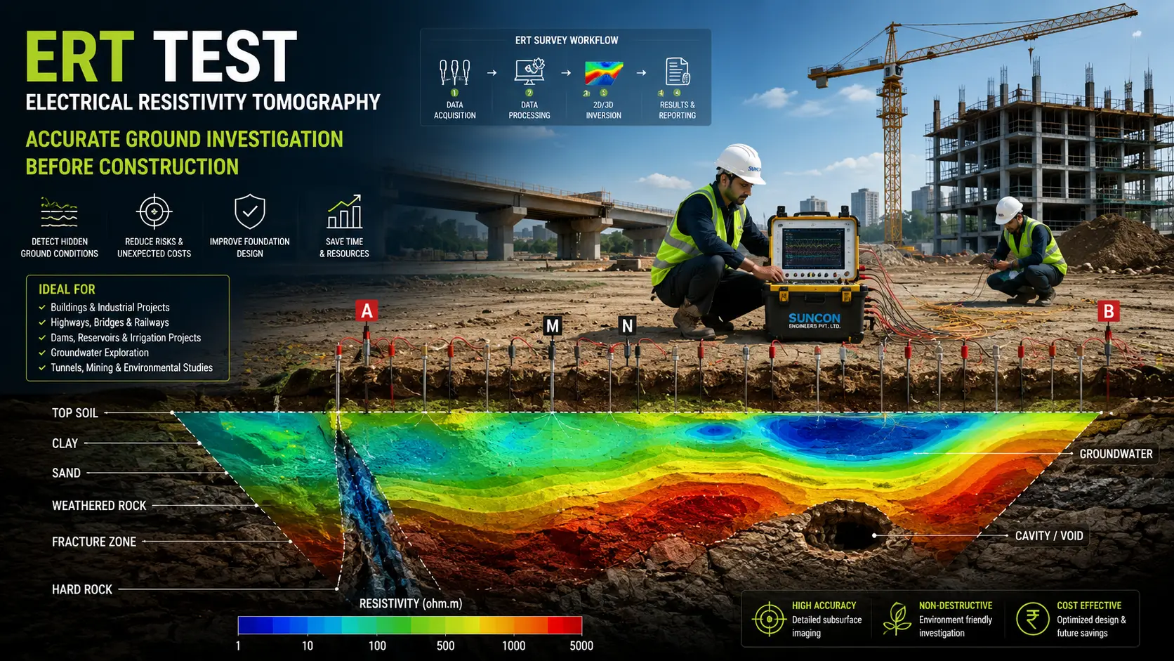
Imagine investing crores in a construction project only to discover hidden rock, groundwater, or weak soil after excavation begins. Suddenly, foundation designs need to change, machinery sits idle, and project costs start increasing. Unfortunately, this happens more often than many developers expect. While the land may appear suitable from the surface, the real challenges often lie several meters underground.
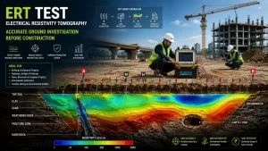
This is where an Electrical Resistivity Tomography (ERT) Test becomes one of the most valuable investigations before construction begins. Instead of relying solely on boreholes that provide information at a few isolated locations, an ERT survey creates a continuous image of what’s happening beneath the ground. It helps engineers identify weak soil, hard rock, groundwater, cavities, fractures, and other hidden geological features before they become expensive problems.
What is an ERT Test?
Electrical Resistivity Tomography (ERT) is a non-destructive geophysical survey method used to investigate underground conditions without excavation. The principle is simple. Different materials beneath the ground conduct electricity differently. Clay, sand, gravel, weathered rock, hard rock, groundwater, and air-filled cavities all have unique electrical resistivity values.
During the survey, a controlled electrical current is passed into the ground through a series of electrodes. The equipment measures how the current travels through the subsurface, and advanced software converts this information into detailed 2D or 3D underground images. Unlike traditional investigations that only reveal conditions at a drilling point, ERT provides a continuous subsurface profile across the entire survey area, making it an ideal tool for modern infrastructure projects.
Why Are More Developers Choosing ERT Surveys?
Construction projects today involve larger investments and tighter timelines than ever before. Unexpected ground conditions can delay a project by weeks or even months.
An ERT survey helps reduce these risks by providing a clear understanding of the underground before excavation begins.
It can identify:
- Weak or loose soil layers
- Rock depth and bedrock profile
- Groundwater levels and aquifers
- Fractured rock formations
- Underground cavities and sinkholes
- Weathered zones
- Faults and shear zones
- Buried channels
- Variations in soil strata
- Potential seepage paths beneath dams and embankments
How Does an Electrical Resistivity Tomography Survey Work?
An ERT survey begins by placing stainless steel electrodes at regular intervals along the proposed survey line. These electrodes are connected to a multi-channel resistivity meter through multicore cables.
Using Ohm’s Law, the equipment calculates the Apparent Resistivity (ρa) of the subsurface. Thousands of measurements are collected automatically using different electrode combinations such as Wenner Array, Schlumberger Array, Dipole-Dipole Array, or Pole-Dipole Array, depending on the investigation objective.
The collected data is processed using specialized inversion software like RES2DINV, RES3DINV, or BERT (Boundless Electrical Resistivity Tomography) to generate detailed resistivity sections. These colour-coded images help engineers interpret underground geological conditions with greater confidence.
Where is an ERT Test Used?
Electrical Resistivity Tomography has become an essential investigation method across various industries. Before constructing high-rise buildings and industrial facilities, engineers use ERT to determine the depth of competent rock, identify weak foundation zones, and assess groundwater conditions.
For highways, railways, airports, and metro projects, the survey helps evaluate changing geological conditions along long alignments. In dam and reservoir projects, ERT is used to detect seepage paths, fractured rock, and permeable zones that could affect structural safety.
Groundwater consultants rely on ERT to locate aquifers, estimate groundwater depth, and identify suitable borewell locations. Mining companies use the technology to map weathered rock, overburden thickness, and structural discontinuities before excavation. Environmental consultants also use ERT to investigate landfill sites, contaminated soil, saline water intrusion, and groundwater pollution.
ERT vs Borehole Investigation – Which is Better?
One of the most common questions clients ask is whether an ERT survey can replace borehole drilling.
The answer is no but it can make borehole investigations much more effective. A borehole provides highly accurate information, but only at the exact drilling location. If the geology changes just a few metres away, the borehole may not detect it. An ERT survey fills these gaps by creating a continuous underground profile between boreholes. Engineers can then decide where additional drilling is actually required, saving both time and investigation costs.
Benefits of Conducting an ERT Survey Before Construction
The biggest advantage of an ERT survey is that it reduces uncertainty. Instead of making engineering decisions based on assumptions, project teams work with accurate subsurface information.
Some of the key benefits include:
- Non-destructive and environmentally friendly investigation
- Continuous subsurface imaging over large areas
- Early detection of weak zones and geological hazards
- Better foundation planning and design
- Reduced excavation risks
- Fewer unexpected site conditions
- Optimized borehole locations
- Lower investigation and construction costs
- Faster project execution
- Improved safety and long-term structural performance
Why Choose an Experienced ERT Survey Consultant?
The accuracy of an ERT survey depends not only on advanced equipment but also on the expertise of the survey team. Proper survey planning, electrode array selection, data acquisition, quality control, inversion processing, and geological interpretation all play a critical role in delivering reliable results. An experienced consultant combines geophysical data with geological knowledge and geotechnical investigations to provide practical recommendations that support better engineering decisions. Ground conditions are one of the biggest unknowns in any construction project. Discovering weak soil, hidden cavities, groundwater, or fractured rock after excavation can significantly increase project costs and delay completion. An Electrical Resistivity Tomography (ERT) Test provides a clear picture of the subsurface before construction begins, helping engineers design safer foundations, optimize investigations, and avoid costly surprises.
Frequently Asked Questions
1. What does ERT stand for?
Ans: ERT stands for Electrical Resistivity Tomography, a geophysical method used to map underground soil and rock conditions.
2. Can an ERT survey detect groundwater?
Ans. It can identify groundwater-bearing zones, aquifers, and saturated soil layers based on variations in electrical resistivity.
3. Is an ERT survey suitable for construction projects?
Ans: Yes. It is widely used before buildings, bridges, highways, industrial plants, dams, and infrastructure projects to evaluate subsurface conditions.
4. How deep can an ERT survey investigate?
Ans: Depending on the electrode spacing and survey design, ERT investigations can range from approximately 5 metres to over 150 metres.
5. Can ERT replace borehole drilling?
Ans: No. ERT complements boreholes by providing continuous subsurface imaging between drilling locations, resulting in a more complete site investigation.
EPC contractors | Infrastructure consultants | ERT Test Company | Electrical Resistivity Tomography | Geophysical survey | Ground investigation | Subsurface investigation, electrical resistivity survey | Geotechnical investigation | Groundwater survey | Foundation investigation | ERT test in soil | Geological & Hydrological Surveys | Geophysical Investigations | Subsurface Investigation | Rock Depth Survey | Electrical Resistivity Imaging