")
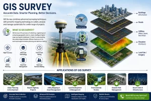
Every successful construction project starts with one thing accurate site information. Whether you are developing an industrial facility, planning a residential township, constructing a highway, expanding a manufacturing plant, or setting up a solar park, decisions made during the planning stage directly affect project costs, timelines, and long-term performance. Unfortunately, many project delays and cost overruns can be traced back to inaccurate or incomplete site data.
This is where drone survey technology is making a significant difference. Project owners, consultants, EPC contractors, architects, and engineers are increasingly turning to drone-based surveying because it provides faster, more detailed, and highly accurate information about a site. Rather than spending days or weeks collecting field data, teams can obtain a comprehensive view of the project area within a much shorter timeframe and begin planning with confidence.
Why Traditional Surveying is Becoming Challenging
As projects become larger and more complex, traditional surveying methods often face several limitations:
- Time-consuming fieldwork
- Limited coverage of large areas
- Difficulty accessing hazardous locations
- Higher manpower requirements
- Delays in project planning and execution
- Challenges in monitoring ongoing site progress
How Drone Survey is Revolutionizing Land Measurement
Faster Data Collection
One of the biggest advantages of drone survey technology is speed. Large areas that may take several days to survey using conventional methods can often be captured within a few hours using drones. This rapid data collection helps project teams start design and planning activities much sooner.
Improved Accuracy
Modern drones use high-precision GPS systems and advanced processing techniques to generate highly accurate survey outputs. Accurate land measurements reduce the risk of design errors and costly modifications during construction.
Coverage of Large Areas
Whether it is an industrial park, mining lease area, highway corridor, solar farm, or township development, drones can efficiently cover extensive areas while maintaining consistent data quality.
Access to Difficult Locations
Steep slopes, water bodies, dense vegetation, and restricted areas can be challenging and unsafe for traditional survey teams. Drones can safely capture information from such locations without exposing personnel to unnecessary risks.
Real-Time Project Insights
Drone surveys provide updated site information whenever required. This enables project managers to monitor progress, compare planned versus actual work, and identify issues before they become major problems.
Industries Benefiting from Drone Surveys
Drone survey technology is now widely used across multiple sectors, including:
- Infrastructure Development
- Road and Highway Projects
- Industrial Expansion
- Mining Operations
- Real Estate Development
- Urban Planning
- Solar and Renewable Energy Projects
- Water Resources and Irrigation Projects
- Land Development and Township Planning
- Railway and Utility Corridor Projects
Key Benefits for Project Owners
Project owners and developers are increasingly adopting drone surveys because they provide:
- Faster project planning
- Better decision-making
- Reduced survey time
- Improved site visibility
- Enhanced safety
- Accurate measurements
- Cost savings through optimized planning
- Better communication among stakeholders
These advantages ultimately contribute to smoother project execution and reduced project risks.
Choosing the Right Drone Survey Partner
While drone technology offers significant advantages, the quality of results depends heavily on the expertise of the survey team. Accurate outputs require experienced professionals who understand surveying principles, data processing, engineering requirements, and project objectives.
A reliable drone survey partner should provide:
- Experienced survey professionals
- High-quality UAV equipment
- Accurate mapping and modeling solutions
- Timely project delivery
- Industry-standard workflows
- Comprehensive reporting and analysis
The construction and infrastructure industry is rapidly embracing digital technologies, and drone survey solutions are leading this transformation. By delivering faster, safer, and more accurate land measurement data, drones are helping project teams plan better, reduce risks, and improve project outcomes. Whether you are planning a new industrial facility, infrastructure project, township development, mining operation, or land acquisition activity, accurate site information is the first step toward success.
Professional drone survey services provide the reliable data needed for confident decision-making, efficient project planning, and successful execution. Investing in the right survey approach today can save significant time, cost, and effort throughout the life of your project.
If you are looking for accurate land measurement, topographic mapping, progress monitoring, volumetric analysis, or construction planning support, partnering with an experienced drone survey team can help ensure your project starts with the right foundation.