
A contour survey is a type of land survey that shows the height and shape of the ground. It helps people understand if land is flat, sloped, or uneven by drawing contour lines these are lines that connect points of the same height.
How Does a Contour Survey Work?
To create a contour map, surveyors go to the site and measure the height of the land at many points. These measurements are then used to draw lines on a map that show where the ground is the same height.
- Planning the Survey
- First, surveyors check the land area to understand how big it is and how the terrain looks.
- They decide how much detail is needed. For example, whether they need to mark every 0.5 meters or 1 meter of height difference.
- Collecting the Data
There are several ways to collect height data:
- a) Using Traditional Tools
- Tools like Auto Levels or Theodolites are used.
- A staff is placed on the ground, and the surveyor measures how high or low each point is compared to a fixed point (called a benchmark).
- b) Using a Total Station
- A Total Station is a modern tool that measures distances and angles quickly.
- It records the height and position of each point on the ground.
- c) Using GPS or DGPS
- GPS devices are used to get the exact location (latitude, longitude, and height).
- DGPS is more accurate and is often used for bigger or remote sites.
- d) Using Drones and LIDAR
- Drones fly over the land and take thousands of pictures or use LIDAR (a laser scanner).
- These images are used to create a 3D model of the land.
- This method is fast and useful for large or hard-to-reach areas.
- Processing the Data
- After data collection, surveyors use software like AutoCAD, Civil 3D, or Global Mapper to process the data.
- The software helps draw contour lines that connect points of the same height.
- The final map shows the shape of the land in a clear and accurate way.
- Creating the Contour Map
- Contour lines (every line shows a certain height)
- Spot heights (exact height of specific points)
- Slopes and gradients
- A scale, legend, and direction (north arrow)
Where Are Contour Surveys Used?
Contour surveys are useful in many fields. Here are some common uses:
- Construction
- To plan roads, buildings, and bridges.
- To decide where to cut or fill the land for levelling.
- Land Development
- For laying out plots in housing or industrial projects.
- To plan drainage systems and water flow.
- Agriculture
- For farm design and irrigation planning.
- To prevent soil erosion.
- Environment and Disaster Planning
- To study flood-prone or landslide-prone areas.
- To design retaining walls or water channels.
- Mining and Quarrying
- To measure volumes of earth or rock to be removed.
- To track changes in the land surface over time.
How We Offer Contour Survey Services
If you want to offer contour survey services professionally, here’s what you need:
- Build the Right Team
- Surveyors: Trained people who can measure land accurately.
- GIS Experts: People who can process data and make maps.
- Drone Operators: Certified pilots who can fly survey drones.
- CAD Technicians: To prepare final drawings and maps.
- Buy or Rent Equipment
- Auto Levels or Total Stations
- GPS/DGPS devices
- Drones with cameras or LIDAR
- Laptops and survey software like AutoCAD, QGIS, or Pix4D
- Follow a Simple Work Process
- a) Before the Survey
- Talk to the client to understand their needs.
- Visit the site and plan the survey.
- Get any required permissions (especially for flying drones).
- b) During the Survey
- Set up control points for accuracy.
- Measure the land using your chosen method.
- Take clear notes and photos.
- c) After the Survey
- Process the data in software.
- Draw the contour map and review it for accuracy.
- Deliver digital or printed maps to the client.
- Provide Clear Deliverables
- A detailed contour map in PDF or CAD format.
- Height details and slope directions.
- If using drones, a 3D model or aerial photos.
- Maintain Quality and Accuracy
- Calibrate your instruments often.
- Always use reference points (benchmarks).
- Check all data before submitting.
Contour surveys are very important in planning, construction, farming, and environmental projects. They help you understand the land better and make smart decisions.
With the right tools, team, and process, you can offer accurate and affordable contour survey services to clients in many industries. Whether you’re using traditional methods or modern drones, what matters most is accuracy, clear maps, and customer satisfaction.
Our Recent Project:
Contour Survey at Shindewadi Dist. Satara (MH).
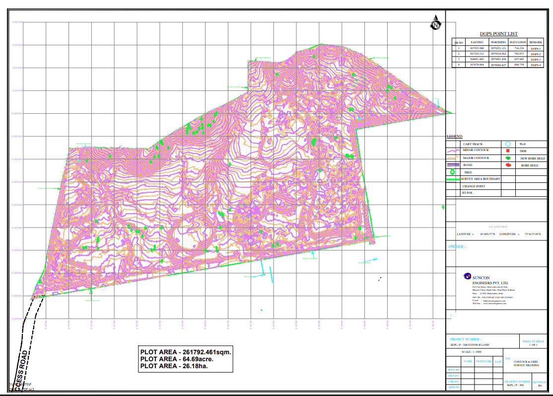
Scope of Work:
➢ Mobilization and Demobilization for survey team.
➢ Drone / DGPS Survey to generate 1 meter’s contour interval for 2 existing ponds
having catchment area of 0.95 km2.
➢ Measuring ponds dimensions including the depth also.
➢ Dead and Live storage capacity of the ponds.
➢ Identifying the LULC class where the topographic survey points will be conducted.
➢ Water quality analysis.
➢ Details of the water quality sampling will be shared with following team.


