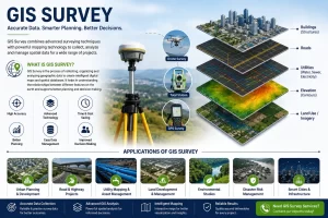
Geographic information system (GIS), as we all know, is a computer-based system for capturing, storing, checking, and displaying data related to positions on earth’s surface. GIS can help individuals and organizations to better understand spatial patterns, topography and relationships between different features on earth surface. They are attached to various operations and numerous applications such as engineering, planning, management, transport/logistics, insurance, telecommunications, and business. Conventional method uses in civil Engineering for surveying, mapping and hydrological modelling is changing day by day due to use of GIS technology.
After the implementation of the state-of-art technology for providing services in the infrastructure sector, Suncon Engineers Pvt Ltd has added a complete new set of technology-based services in its bucket parallelly to the ones that are used before.
By looking at the current scenario (globally), with the use of GIS technology, one can work very effectively in the sectors viz., Natural Resources Preservation, Environmental Risk Assessment & Insurance, Flood Management, Smart City & Urban Planning, Irrigation – Waste & Disaster Management, Defence & Security, Forest Management, Land Research Management.
As per the sectors mentioned above, Suncon has started successfully delivering its services such as Photogrammetry, GIS Mapping (such as Utility Mapping, Topographic Mapping, Thematic Mapping, Remote Sensing, Geological Mapping, Contour Mapping), Surveys (such as Aerial Lidar, Mobile Lidar, UAV Lidar, Terrestrial Lidar), BIM in the above-mentioned Sectors.
Using the GIS Technology – We can do
For Natural Resource Preservation: Master Planning for Government/ Institutions & Large Industries, recent trends in depletion & contamination and suggesting short- and long-term intervention, control & conservation measure including governance, regulatory compliance, CAPEX & OPEX for management.
Along with that, services can be given in the Water, Agriculture, Land, Bio-Diversity, Soil etc.
For Environmental Risk Assessment & Insurance: Advisory services on above for industries, infrastructure and large development projects, Calculating & working on Environmental Risks, Emission – Discharges & Contamination, Geo-Hazards & Bio-Diversity loses.
For Agriculture Sector: The agricultural sector is the mainstay of the rural Indian economy around which socio-economic privileges and deprivations revolve, and any change in its structure is likely to have a corresponding impact on the existing pattern of social equality.
The future growth in agriculture must come from new technologies which are not only cost-effective but also in conformity with natural climatic regime of the country.
GIS in agriculture helps farmers to achieve increased production and reduced costs by enabling better management of land resources. The risk of marginalization and vulnerability of small and marginal farmers, who constitute about 85% of farmers globally, also gets reduced.
Agricultural Geographic Information Systems using Geomatics Technology enable the farmers to map and project current and future fluctuations in precipitation, temperature, crop output etc.
Farming is getting smarter with the availability of advanced technologies like precision equipment, the Internet of Things (IoT), sensors and actuators, geo-positioning systems, Big Data, Unmanned Aerial Vehicles, robotics etc.
For Infrastructure Works: In Infrastructure Development, GIS plays a major role. It enables local bodies to act and make decisions by studying and doing Geographic & Spatial Analysis.
In GIS Application, major components is Maps which are neither considered as mere graphic representation nor spatial database information. Maps are used under GIS Environment as definite integrals of information of Static Data hand-in-hand to Ground truth.
GIS has enabled businesses by increased efficiency in the delivery of services. With the help of GIS providing spatial solution, working in Transportation, Water Resources, Facilities management, urban planning, construction sectors are now very useful and can be done in ease with increased accuracy and better management.
GIS emerged as an effective tool to visualize the topographical condition of Project Site. The modelling of construction site facilitates in construction controlling and planning process.
Utility Mapping | Topographic Mapping | Thematic Mapping | Remote Sensing | Geological Mapping | Contour Mapping