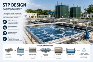
As we all know, India is a growing and rapidly developing country, and along with the other infrastructures, it is compulsory that the citizens receive proper basic infrastructures such as roads, electricity, water supply, education, and a lot more. To get in shoes with this, we can see the Indian government is working on these infrastructures, not like before. For example, we can see the scheme launched by the Indian government for providing water to every house and household in India. Along with the increasing day-by-day network of roads in India, we can see development in the sector of drinking water supply and sanitization. The scheme is named as Jal Jeevan Mission and is actively being carried out in most of the states in India, such as Assam, Chhattisgarh, Maharashtra, Karnataka, and many more. Most of the work is under the Detailed Project Report Preparation Stage and can be seen under construction very soon.
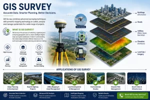
For the preparation of Detailed Project Report, a detailed engineering survey is required for studying all the topographies, contours, geographical levels, and other aspects, such as reservoirs, that can be natural or manmade etc. By studying these aspects, one can determine how to make it possible for every household to get its own water supply connections. For doing these surveys, consultants preparing DPRs use a total station as an equipment to conduct the engineering surveys. This equipment was a major update in the field of surveying. At first, a plane table survey was used to be conducted using tapes, chains, prisms, etc for measurements. Later, it got technologically updated with the new innovation of theodolite equipment.
A theodolite is a precision optical instrument for measuring angles between designated visible points in the horizontal and vertical planes. The traditional use has been for land surveying, but it is also used extensively for building and infrastructure construction and some specialized applications such as meteorology and rocket launching. It consists of a moveable telescope mounted so it can rotate around horizontal and vertical axes and provide angular readouts. These indicate the orientation of the telescope and are used to relate the first point sighted through the telescope to subsequent sightings of other points from the same theodolite position. In a transit theodolite, the telescope is short enough to rotate about the trunnion axis, turning the telescope through the vertical plane through the zenith; for non-transit instruments vertical rotation is restricted to a limited arc. The theodolite becomes a very helpful successor to using a plain table, chains, tapes & ropes. It was an era for theodolite in the field of surveying. Theodolite got its successor in the form of Total Stations, which are really the best solution for survey work; measuring levels, distances, and topographies is done with a lot of ease with the use of the equipment.
A total station is a surveying equipment combination of an electromagnetic distance measuring instrument and an electronic theodolite. It is also integrated with a microprocessor, an electronic data collector, and a storage system. The instrument can be used to measure horizontal and vertical angles as well as the sloping distance of the object to the instrument.
Total stations are much more convenient and faster than the theodolite equipment. Total Stations are a proven solution for:
Distance Measurement: Electronic distance measuring (EDM) instrument is a major part of a total station. Its range varies from 2.8 km to 4.2 km. The accuracy of measurement varies from 5 mm to 10 mm per km measurement. They are used with automatic target recognizers. The distance measured is always the sloping distance from the instrument to the object.
Angle Measurement: The electronic theodolite part of the total station is used for measuring vertical and horizontal angles. For measurement of horizontal angles, any convenient direction may be taken as the reference direction. For vertical angle measurement, the vertical upward (zenith) direction is taken as the reference direction. The accuracy of angle measurement varies from 2 to 6 seconds.
Data Processing: This instrument is provided with an inbuilt microprocessor. The microprocessor averages multiple observations. With the help of slope distance and vertical and horizontal angles measured, when height of the axis of the instrument and targets are supplied, the microprocessor computes the horizontal distance and X, Y, Z coordinates. The processor is capable of applying temperature and pressure corrections to the measurements if atmospheric temperature and pressure are supplied.
Differential Global Positioning System (DGPS) is an enhancement to the Global Positioning System that provides improved location accuracy, from the 15-meter nominal GPS accuracy to about 10 cm in case of the best implementations. The base station compares its own known location to that computed from a GPS receiver.
DGPS survey achieves higher positional accuracy by making use of the differential capabilities of two GPS antennas linked by a radio signal. We conduct DGPS surveys using the most up-to-date and effective differential GPS equipment or DGPS instrument. DGPS is a system to provide positional correction to GPS signals. DGPS signals use the known position as a reference to adjust real-life GPS signals to eliminate pseudo-range and to improve the accuracy of user position range and to improve the accuracy of user positions. Here the post gives information about the advantages of DGPS to better understand this topic.
Advantages of DGPS:
- While in use, GPS is quite accurate; using DGPS pushes its accuracy even further.
- GPS or DGPS makes A/L guidance asprecise as opposed to ILS as well as MLS.
- DGPS has to know the perfect location on the earth.
- Provide accurate data within a minute.
These added advantages of DGPS over the advantages of Total Station help the team to survey more area more precisely and with greater accuracy. With these added advantages & features, the gathered data helps the consultants to prepare a detailed project report better and more accurately than before.