Survey of India is established in 1767 which is 252 years ago. In this long period survey has achieved advance technology. In the initial period dumpy levels, theodolites and chain were used. Dedication and hard work surveyors and engineers have achieved a lot through these instruments. Pune-Mumbai Railway line has several tunnels and these are completed with survey instruments like theodolite and dumpy levels. Over period of time, technology evolved to find out distometer launched on theodolite and auto level. It was joyful for engineers and surveyors to complete survey work without tape. Further to that total station instrument and digital level made atomization in the instrument. For global location DGPS (Differential Global Positioning System) was used.
provide improved location accuracy, in the range of operations of each system, from the 15-meter nominal GPS accuracy to about 10 cm in case of the best implementations.
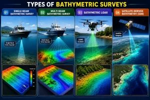
Now we are in the era of Lidar technology. Details are given below.
Lidar (also called LIDAR, LiDAR, and LADAR) is a surveying method that measures distance to a target by illuminating the target with pulsed laser light and measuring the reflected pulses with a sensor. Differences in laser return times and wavelengths can then be used to make digital 3-D representations of the target. The name Lidar, now used as an acronym of light detection and ranging (sometimes light imaging, detection, and ranging), was originally a portmanteau of light and radar.
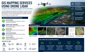
● VTOL-aircraft (Vertical Take-off and landing) and able to carry variety of payloads.
Role of Advance survey in Project in India, sectors like Road, Railway, Bridges, Water Supply, Sewerage, Storm Water , Industrial, Commercial and Residential Development. There are requirements to conduct survey, soil investigation including Geotechnical laboratory testing, Hydraulic Design, Geometric design, Architectural Design, cost estimates, detailed drawings, tender document preparation, tender evaluation, quality checking, supervision, project ,management services, Pune, Delhi, Mumbai, Chennai, Hyderabad, Bengaluru, Kolkata, Ahmedaba. To achieve highest accuracy and project completion in time, advance survey techniques are useful.