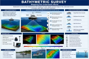
Bathymetric surveys play a critical role in understanding the underwater topography of rivers, lakes, reservoirs, harbours, coastal zones, and offshore areas. Similar to how topographic surveys map the land surface, bathymetric surveys measure water depths and underwater features to create detailed maps of the submerged terrain. These surveys are widely used in dredging projects, port development, dam management, flood studies, coastal engineering, environmental assessments, and infrastructure planning.
Common Bathymetric Survey Methods
Survey method depends on factors such as water depth, survey area, required accuracy, project objectives, and environmental conditions.
- Single Beam Echo Sounder (SBES) Survey
The Single Beam Echo Sounder is one of the most commonly used bathymetric survey methods.
How It Works: A transducer mounted on a survey vessel emits a sound pulse directly downward into the water. The pulse travels to the bottom surface and reflects back to the receiver. The travel time is measured and converted into depth.
Advantages
- Cost-effective
- Simple operation
- Suitable for rivers, lakes, and reservoirs
- Reliable depth measurements
Limitations
- Captures data only along the vessel’s track line
- Lower coverage efficiency compared to multibeam systems
Typical Applications
- Reservoir surveys
- Inland waterways
- Dam monitoring
- Small-scale dredging projects
- Multibeam Echo Sounder (MBES) Survey
Multibeam technology has transformed modern hydrographic surveying by providing comprehensive seabed coverage.
How It Works: Instead of a single acoustic beam, the system emits multiple sound beams across a wide swath beneath the survey vessel. This enables simultaneous collection of thousands of depth points.
Advantages
- Full seabed coverage
- High-resolution mapping
- Faster data acquisition
- Detection of underwater features and obstructions
Limitations
- Higher equipment and operational costs
- Requires experienced survey personnel
Typical Applications
- Port development
- Offshore engineering
- Coastal surveys
- Navigation channel mapping
- Marine infrastructure projects
Key Benefit: Multibeam surveys significantly improve the accuracy and completeness of underwater terrain models.
- Acoustic Doppler Current Profiler (ADCP)
Although primarily used for current measurements, ADCP systems can also provide bathymetric information.
How It Works: The instrument emits acoustic signals that measure water velocity at different depths while simultaneously recording bottom tracking data.
Advantages
- Measures flow velocity and depth simultaneously
- Useful in hydraulic studies
- Supports river engineering projects
Typical Applications
- River discharge measurements
- Flood modeling
- Hydraulic assessments
- Sediment transport studies
- LiDAR Bathymetric Survey
Bathymetric LiDAR combines laser scanning technology with hydrographic surveying techniques.
How it Works: An aircraft or drone-mounted laser system emits green laser pulses capable of penetrating clear water. Reflections from the water surface and bottom are recorded to determine depth.
Advantages
- Rapid coverage of large areas
- Access to shallow or difficult-to-reach zones
- Simultaneous topographic and bathymetric data collection
Limitations
- Performance depends on water clarity
- Higher operational costs
Typical Applications
- Coastal mapping
- Shoreline monitoring
- Environmental studies
- Floodplain analysis
- Drone-Based Bathymetric Survey
Advancements in UAV technology have introduced innovative approaches for shallow-water surveying.
How It Works: Drones equipped with LiDAR sensors, photogrammetry systems, or specialized bathymetric equipment capture data over water bodies.
Advantages
- Reduced field time
- Improved safety
- Access to hazardous or remote locations
- High-resolution data collection
Typical Applications
- Small reservoirs
- River sections
- Mining pits
- Environmental monitoring
- Satellite-Derived Bathymetry (SDB)
Satellite-derived bathymetry uses remote sensing imagery to estimate water depth in clear, shallow waters.
How It Works: Different wavelengths of light penetrate water to varying depths. Specialized algorithms analyze reflected light patterns to estimate underwater terrain.
Advantages
- Large-area coverage
- Cost-effective for preliminary studies
- Useful in remote regions
Limitations
- Lower accuracy compared to direct survey methods
- Effective mainly in clear water conditions
Typical Applications
- Coastal planning
- Environmental assessments
- Regional mapping projects
Supporting Technologies Used in Bathymetric Surveys
To improve accuracy, bathymetric surveys often integrate several positioning and motion-monitoring technologies:
– GNSS/GPS Positioning: Provides precise horizontal and vertical coordinates for every depth measurement.
– Motion Reference Units (MRU)
Compensate for vessel movements caused by:
- Pitch
- Roll
- Heave
- Yaw
– Sound Velocity Profilers: Measure changes in sound speed within the water column to ensure accurate depth calculations.
– Tide Gauges: Monitor water level fluctuations and provide depth corrections for survey data.
Challenges in Bathymetric Surveys
Despite technological advancements, bathymetric surveys can face several challenges:
- Water Level Variations: Changing tides, reservoir levels, and river flows can affect depth measurements.
- Turbidity: Highly turbid water can reduce the effectiveness of LiDAR-based methods.
- Strong Currents: River and coastal currents may impact vessel navigation and data quality.
- Underwater Obstructions: Submerged debris, vegetation, and structures can create data gaps or anomalies.
- Weather Conditions: Wind, waves, and storms can influence survey accuracy and operational safety.
Selecting the Right Bathymetric Survey Method
The most suitable method depends on project requirements:
| Survey Requirement | Recommended Method |
| Reservoir Capacity Survey | Single Beam Echo Sounder |
| Port and Harbor Mapping | Multibeam Echo Sounder |
| River Flow Assessment | ADCP |
| Coastal Zone Mapping | Bathymetric LiDAR |
| Large Remote Areas | Satellite-Derived Bathymetry |
| Shallow Water Surveys | Drone-Based Bathymetry |
Why Bathymetric Surveys Are Important
Bathymetric surveys provide valuable information for:
- Port and harbours development
- Dredging quantity calculations
- Reservoir capacity assessment
- Bridge and jetty construction
- Coastal protection projects
- Flood risk and hydraulic studies
- Dam safety monitoring
- Underwater pipeline and cable routing
- Environmental impact assessments
- Navigation channel maintenance
Accurate underwater mapping helps reduce project risks, improve design accuracy, and support long-term asset management.
Future of Bathymetric Surveying
The future of bathymetric surveying is being shaped by advancements in autonomous survey vessels, artificial intelligence, real-time data processing, cloud-based analytics, and integrated drone technologies. These innovations are enabling faster surveys, improved accuracy, and more efficient management of water-related infrastructure projects.
Bathymetric surveys provide the foundation for understanding underwater environments and supporting critical engineering, environmental, and infrastructure projects. From traditional single beam systems to advanced multibeam sonar, LiDAR, drones, and satellite-based techniques, modern bathymetric survey methods offer a range of solutions tailored to different project needs.
Choosing the right survey approach ensures accurate depth measurements, reliable underwater terrain models, and informed decision-making for dredging, navigation, coastal development, reservoir management, and marine construction projects. As technology continues to evolve, bathymetric surveying will remain an essential tool for sustainable water resource management and infrastructure development.