
When it comes to construction, infrastructure development, real estate, and land planning, accurate information about the site is the first step toward making good decisions. A reliable Land Survey helps engineers, architects, developers, and property owners understand the size, shape, elevation, and existing features of a site.
For many years, Traditional Land Survey techniques have been the standard approach. Surveyors use instruments such as total stations, GPS/GNSS equipment, levels, and other tools to collect measurements directly from the ground.
Technology has changed the way land is surveyed. Drone Land Survey techniques use drones equipped with high-resolution cameras and, in some cases, LiDAR sensors to capture large amounts of information from above. This data can then be processed to create detailed maps, 3D models, point clouds and elevation data.
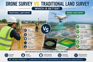
Drone Survey vs Traditional Land Survey: Key Differences
Both methods have their place in professional surveying. However, there are some important differences.
- Speed of Data Collection
One of the biggest Drone Survey Benefits is speed. A drone can cover a large area in a relatively short flight. This makes it useful for large construction sites, mining areas, roads, industrial land, agricultural areas, and infrastructure projects.
Traditional surveying can also deliver excellent results, but teams may need more time to physically move around the site and collect individual points. For a small site, the difference may not be significant. For a large site, drone surveying can provide a major time advantage.
- Coverage Area
Traditional surveying is generally point-based. Surveyors collect measurements at selected locations and use those points to develop the required survey information.
Drone surveying captures a much larger amount of spatial information across the site.
This makes Drone Mapping particularly useful when project teams need a complete visual representation of a large area rather than measurements from only selected points.
- Safety
Safety is another important consideration.
Some sites contain steep slopes, unstable ground, excavation areas, construction equipment, water bodies, or other hazards. Sending survey teams into every part of such a site may increase exposure to risk.
A drone can collect aerial information while keeping survey personnel away from certain hazardous areas.
This does not eliminate the need for people on-site, because ground control, verification, and specific measurements may still be required. However, it can reduce the amount of time surveyors need to spend in difficult locations.
- Level of Detail
Modern Drone Surveying can produce extremely detailed visual and spatial information.
Instead of collecting only individual points, drone photography can capture the entire surface of a site. After processing, the information can be used to understand terrain, structures, stockpiles, roads, drainage patterns, and other visible features.
Traditional surveying, however, can be more suitable when a project requires precise measurement of specific points, boundaries, or construction elements.
In many professional projects, combining both methods provides better results than relying on only one.
Accuracy: Is Drone Survey More Accurate?
This is one of the most common questions about Modern Land Surveying.
Drone survey accuracy depends on several factors, including the drone and camera system, flight planning, ground control points, GNSS technology, image quality, terrain, weather, processing software, and the expertise of the survey team.
Traditional surveying equipment such as total stations and high-quality GNSS systems can provide highly precise measurements for specific points.
Therefore, it would be incorrect to say that drones are always more accurate than traditional surveying.
Instead, each method has different strengths. Drone surveys are excellent for collecting extensive spatial information quickly, while ground-based surveying can provide highly precise measurements where specific points need to be established or verified.
Traditional Surveying Methods Still Matter
The rise of drone technology does not mean Traditional Surveying Methods are no longer useful.
Traditional methods remain important for:
- Property boundary surveys
- Construction setting out
- Establishing control points
- Precise engineering measurements
- Verification of drone survey data
- Monitoring specific structural points
- Areas where drone flights are restricted
- Projects requiring direct ground measurements
Experienced survey professionals often use drones and conventional instruments together.
Drone can quickly map a large construction site, while a total station can be used to verify important points and establish accurate construction control. This combined approach can provide both speed and confidence.
When Is Drone Surveying the Better Choice?
Drone Surveying can be a strong option when:
- The site is large.
- Fast data collection is important.
- A detailed aerial map is required.
- The project requires 3D terrain information.
- Regular site monitoring is needed.
- Stockpile or earthwork volumes need to be calculated.
- The site contains difficult-to-access areas.
- Project teams need visual documentation.
- Large amounts of spatial data are required.
How Drone Survey Benefits Construction Projects
The Drone Survey Benefits go beyond simply collecting aerial photographs. Drone data can support several stages of a construction project. During the planning stage, it can help project teams understand existing site conditions. During construction, regular flights can document progress and provide updated site maps. For earthwork projects, drone data can help calculate cut-and-fill quantities and stockpile volumes.
For infrastructure projects, aerial mapping can help teams review roads, drainage systems, embankments, bridges, and surrounding areas.
The visual nature of drone data also makes it easier for project managers and clients to understand site conditions without physically walking across the entire project area.
FAQs: Drone Survey vs Traditional Land Survey
- Is a Drone Survey better than a Traditional Land Survey?
It depends on the project. Drone Survey is ideal for large areas, quick mapping, 3D models, and site monitoring, while Traditional Land Survey is useful for precise point measurements, boundaries, and construction setting-out. - How accurate is a Drone Land Survey?
A Drone Land Survey can provide high accuracy when proper flight planning, ground control points, quality equipment, and professional data processing are used. Accuracy also depends on site conditions and project requirements. - What are the main benefits of Drone Surveying?
The main Drone Survey Benefits include faster data collection, large-area coverage, safer surveying in difficult locations, detailed aerial mapping, 3D modelling, and efficient volume calculations. - Can Drone Survey and Traditional Surveying Methods be used together?
Yes. Combining Drone Surveying with Traditional Surveying Methods can provide comprehensive site data. Drones can cover large areas quickly, while ground surveying equipment can be used to verify important points and establish control. - Which Land Surveying Method is best for construction projects?
The best method depends on the project size, terrain, accuracy requirements, and required deliverables. For large construction sites, a combination of Drone Land Survey and traditional surveying is often an effective approach.