CHAPTER 1: PROJECT DETAILS:
Background: Maharashtra Minerals Corporation Ltd (MMCL) is a joint sector corporation founded in 1961 by late Shri GB (Bhausaheb) Newalkar, a freedom fighter and visionary who pioneered entrepreneurship development in Maharashtra by revitalizing the small-scale industries movement. He founded MMCL to bring positive changes in our backward districts, an objective that is incorporated in letter and spirit in our organization and enshrined in our Memorandum of Association.
A joint sector corporation (Public Private Participation) promoted with Government of Maharashtra, MMCL is engaged in the business of mining, mineral processing and marketing of mineral products. It has leases of Kyanite, Silica Sand, Bauxite and Fluorspar at various places in Maharashtra and in Chhattisgarh. With a nucleus like headquarters in Mumbai, MMCL has pioneered
in excavation of these minerals for export and for value-added products.
Site Location:
- The site is located near Dist. Sindhudurga.
- The Silica Sand Mine is located at Dist. Sindhudurga, Maharashtra.
Climate:
Sindhudurg district is the southernmost district of Maharashtra. It has deposits of Iron, Bauxite and Manganese. Sindhudurg is bordered on the north by Ratnagiri district, on the south by the state of Goa, on the west by the Arabian Sea, and to the east across the crest of the Western Ghats or Sahyadris is Kolhapur district. Sindhudurg is part of the Konkan (coastal) region, a narrow coastal plain in western Maharashtra which lies between the Western Ghats and the Arabian Sea.
Scope of work:
- Site visit before start of survey work.
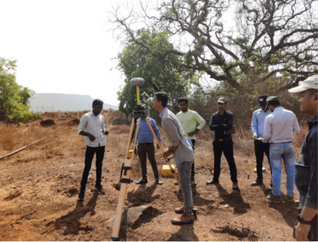
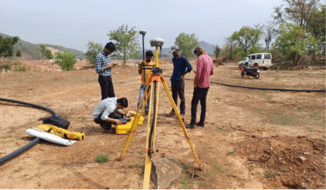
- Establishment of Ground Control Point (GCP) using DGPS.
- Connection of GCP / TBM using Digital Level.
- Conducting Drone Survey for entire area (approx.120 Ha.)
- Processing of Base.
- Workout quantities for cut and stocks areas.
Deliverables:
Deliverables under the Drone Survey and Mapping portion of the scope of work shall include:
➢ Verify and correctness of existing DGPS mapped GCP’s and Lease Boundary Co-ordinates.
➢ High Resolution Orthomosaic image of Lease area including 100m Buffer zone and also stockpiles area mapping which is outside the lease area.
➢ Digital Elevation Model DEM/DTM/DSM.
➢ AutoCAD DWG files with all the Vector data with contour details / mapping showing existing mining area and stockpiles in the surrounding area.
➢ All other data as per IBM requirement.
➢ All the captured data to be given in soft and hard form.
Objectives:
1. The objective of this assignment is to study, analyze the mining area along with the detail status of Topography of mines with contours including lease boundary.
2. To work out the quantum of cutting of mines along with the quantum of stocks of silica materials.
3. To take the aerial image of Kasarde mining area with the help of Drone Survey.
Methodology:
We, at Suncon Engineers, propose the following methodology according to the scope of work, team and time period for the given task.
UAV Survey Methodology
Every UAV project we undertake, we ensure quality service and outputs for our clients. Take a look into our UAV workflow:
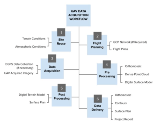
1. Site Recce
On field visit and note observations related to wind conditions, landing and take-off site conditions, identification of locations of GCPs (if required) to be placed, terrain undulations, above-ground obstructions, if any (such as transmission lines, trees, etc.) exists.
2. Mission Planning
a. GCP Network: We determine GCP positions where there will be maximum number of satellites at the time of survey so as to get the required accuracy for those GCP coordinates (Depends on Case-to-Case basis)
b. Flight Planning: The flight path is determined. We take the buffer of about 100m of the existing scope provided to us as mentioned in the scope of work.
3. Data Acquisition
a. DGPS Survey to establish GCPs (Depends on Case-to-Case basis)
b. UAV Data Acquisition: The UAV collects the images at a particular altitude or at the required ground resolution and at a predetermined lateral and frontal overlap, mentioned in the flight planner. For urban mapping, we usually prefer double grid data acquisition technique.
4. Pre-Processing
a. Orthomosaic, Point Cloud, Digital Surface Model (DSM) Generation: The acquired images are then uploaded on the cloud and further processed. The above-mentioned deliverables are generated within a stipulated time.
5. Post-Processing
a. DTM generation
b. Contour generation
c. Surface Plan creation (Based on user requirements, the above-mentioned deliverables are then produced).
6. Delivery
a. Orthomosaic
b. Digital Surface Model & Digital Elevation Model
c. Contours
d. Project Report
Please note that the above-mentioned methodology is generalized and for reference purpose only. Actual approach and methodology for any project depends on the requirement of the client and feasibility of the site.
QC Procedures
• The project quality team will ensure accuracy of Ortho-photo and DEM is matching with the real- world coordinates.
• The team QC check the correctness of topography map prepared from aerial photographs.
• The team will ensure efficiency in processing and handling of the data.
• The team will ensure the resolution of the Ortho-photo as per the captured height.
Deliverables under the Drone Survey and Mapping portion of the scope of work shall include:
a) Aerial Photos in JPG format. Provide high resolution and high accuracy images which can be used for accurate measurement of distances and area.
b) Asset Mapping of existing alignment of drainage system.
c) AutoCAD DWG files with all the Vector data with contour details/mapping showing existing drainage networks.
d) Producing drawing files by digitizing Orthophoto including all existing drainage networks.
e) Raw 4K quality Videos with Geo Tagged files.
f) Merged seamless Geo-Tagged Video of 1920×1080 format (Full HD) resolution with all annotations.
g) Digital Terrain Model (DTM).
CHAPTER 2: ASSESSMENT OF THE PROJECT
Topographical Survey & Contour Map:
Conducting detail topographical survey of the project of mining area is essential with the help of Drone and DGPS. For this purpose, analyze the mining area along with the detail status of Topography of mines with contours including lease boundary. We have established 18 nos. of Ground control point for with the help of DGPS. Then conducting Drone survey for entire area. This survey will be conducted five no’s flight planning. We have processed this data in GIS software. We have prepared detailed topographical drawing with contours. We have identified stocks areas of silica material and workout quantities.