Road Construction Department (RCD), Government of Jharkhand in order to explore the necessity and feasibility of providing Rotary with junction improvement at the intersection of Chaibasa Bypass road and Chaibasa-Kokcho-Bharbhariya Road (Tambo Chowk) in the state of Jharkhand for better connectivity, catering future traffic, efficient commercial transportation, traffic decongestion.
Site Observations:
- The old road and bypass cross each other at skewed angle.
- Two ‘Y’ junctions are formed but are separated by about 150 meters.
- Existing carriage ways are narrow.
- No proper turning radii provided.
- The available actual land (space) between opposite structures various from 15m. to 40m.
- There are few trees existing in the right of way as well as electric poles
- Separate footpaths are not provided.
- Almost all structures are of ground floor.
- It is a commercial land use of shops, banks, service centres.
- Encroachment on government lands particularly at corners.
- No proper design of islands, no median
Existing Traffic Movement:
- There is mix of vehicles, pedestrians
- Right turning traffic has to wait longer creating queues
- No proper segregation of turning movements
Analysis of Topographic Survey:
Topographical survey using total station has been carried out to collect sufficient data to form the digital terrain model and to prepare the map of the physical features of the area.
Following existing features have been captured during the survey:
- Building lines, type of buildings (shops or houses, number of storeyed), trees and Right of Way boundary if available at site by presence of boundary stones.
- Road edges, centerline, shoulders/footpaths, median etc.
- Identifying all religious places, its locations, boundary lines and clear dimensions of compound walls and entrances.
- All service lines both above and below ground such as OFC cables, water and sewer pipes, gas pipes, electrical poles and cables, telephone poles and lines etc.
- Location of traffic islands, median, rotaries, dividers etc.
- Location of road side drains, clearly identifying the type (open/close), width of drain, including the beginning and end of drains.
- Positions of transformers, mast, towers etc.
- Apart from the above, the names of intersecting roads and other landmarks are also recorded and incorporated in the drawing.
Videography through Drone –
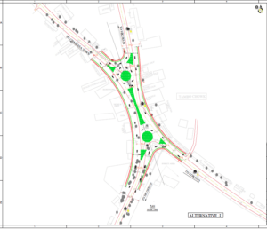
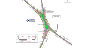
Videography survey has been conducted with Drone Camera. The video shooting recording in done at Tambo Chowk. Also video shooting is done on road towards Sikursai and DC Office, also road towards Kokcho & Chaibasa side. During video shooting all traffic movement on road & junction of Tambo Chowk is captured. The existing structure such as electric poles, trees are also captured. Based on these observation, rotary junction is proposed.
Conclusion & Recommendation
- General: For junction improvement schemes the factors considered are
- Physical – Junction layout, land width, turning radii, physical obstructions, land use, facilities for pedestrians, underground and over ground utilities, land ownership, type of structures possibility of road widening and acquisition, existing street furniture.
- Traffic – Present traffic demand, traffic turning movement pattern, composition, pedestrian movement, percentage of straight, right and left turning, average speeds, formation of queues, parking of vehicles, accesses to properties etc.