Do You Have A Construction Project We Can Help With?
How Innovation Technology And Ideas In Design Of Storm Water Drains Could Resolve Problems Of Flood Prone Cities.
Innovation technology in storm water drainage design to resolve problems of flooding of cities adjoining to sea shore with few natural primary drains.
Thoothukudi(Tamil Nadu-India) is a port town situated in the Gulf of Mannar about 125 km (78 mi) North of Kanya-Kumari and its environs form part of the coastal belt which forms a continuous stretch of the flat country relieved here and there by small rockout crops. Thoothukudi is a Municipal Corporation having spread of about 9000 ha area. It has outside catchment area of about 10000ha draining towards the city. It has very flat terrain so flooding issues occur during continuous heavy rains in the entire catchment. The city has only 2 main drains viz. Upparu River flowing through its southern part and a constructed buckle canal flowing through the heart of the city and having total catchment area of over 6000 ha. In addition to these two main drains one stream called as Periapallam is flowing on the northern boundary of the city.
TNUIFSL has appointed Suncon Engineers Private. Ltd, Pune as a consultant for Storm Water Drainages for Thoothukudi Corporation.
The brief scope of assignment is as follows :
- Conducting Topographical Survey of entire Thoothukudi city having area 9000 ha. Preparation of contour map at 1m interval with the help of total station, auto level, digital level and GPS.
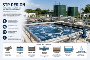
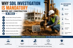
- Conducting Soil Investigation by Augur up to 3m depth. Conducting geotechnical Laboratory tests on collected samples. Soil tests like grain size analysis, moisture content, Atterburg limits
- Drilling of trial bores for soil investigation for S.V.Kulam and approaches. Geotechnical foundation Recommendation report includes lab tests on soil and rock.
- Preparation of GIS map having layers clearly defined all attributes captured in survey.
- Divide the surveyed project area into various drainage zones (preferably based on sub catchment boundaries) considering the natural topography and contributory areas with a view to adopt decentralized approach as far as possible and economize the cost of overall system and also to avoid pumping stations on the basis of contour survey map.
- Preparation of Storm Water Design as per CPHEEO manual & Mo UD Guidelines. Utilizing proven and readily available computer dynamic modeling software i.e. storm cad v8i 5 series (that allows for visually depicting the design changes and their impact), carry out analysis of existing situation of storm water drains to identify deficiencies and develop alternative strategies and options for expansion / augmentation of the existing system to address system deficiencies
- Preparation of drainage district-wise drawings on the basis of contour survey with the help of total station, digital level and GPS.
- Preparation of Environmental Management Plan, Social R & R Plans, Financial & Economical Analysis.
- All the designs, field investigations, surveys other analyses and reports shall be as per Mo UD Guidelines, Indian Standards (IS), Indian Roads Congress (IRC), and CPHEEO as applicable.
- Detailed Project Report (DPR) includes hydraulic designs, structural design of drain, cost estimates, designed drawings, tender documents.
Best Management Practices(BMP):
Conserve Existing Amenities, Minimize Impacts, Minimize Directly Connected Impervious Areas, Stabilized Natural Channel, Constructed Grass, Riprap, or Concrete-Lined Channel, Constructed Wetland Channel
BMPs suitable for SWD Plan :
Sediment & Erosion Control, Erosion control blanket, Permanent Seeding, Storm water drain in let protection, Good housekeeping practices, Provision of small check dams, Sediment trap drops.
TECHNOLOGICAL INTERVENTIONS CONSIDERED
Infiltration System through Rain Water Harvesting Arrangements :
Infiltration happens naturally in undeveloped environments to various degrees according to the soils ability to absorb water. When the hardened surfaces of development occur, supplemental systems are necessary to revert infiltration back to pre-development conditions. Common methods of accomplishing this are the use of pervious surfaces and infiltration devices to artificially recharge ground water through rain water harvesting structures.
Diversion of Flow of Part Catchment Area Into Other Water Sheds :
Despite to carry out general scope like survey, investigation, hydraulic design & capacity checking of existing drains, it is necessary to explore to diversion of catchment areas into the natural flow/channel/river/nallah which is flowing adjacent to city. To reduce the discharge into the buckle canal (Flowing through City Areas), it is essential to divert part catchment area to other water sheds if such diversion is possible. By adopting this method, the catchment area on the buckle canal will get reduced which will reduce the storm flow through the buckle canal to a desired quantity of flow.
Use of Existing Tank as Holding Pond :
If the flow from any catchment area is possible to be admitted into an existing or proposed storage tank with arrangements to discharge the stored water at controlled rate after the reduction in the rainfall intensity, then due to the storage capacity of that tank, the time of concentration increases and thereby the reduction in rainfall intensity and thereby reduction in flow in the downstream of the storage tank can be achieved. Similarly, it is possible to defer the flow/ to control the outlet flow which helps in reducing the peak flow of the water course d/s of that tank. Thus such method is very useful in reduction of storm flow and thereby in reducing the size of storm drains. Eventually it is more effective in flood control management.
Strom Water Pumping :
Such arrangements sometimes become essential for cities in the coastal area due to very flat ground slopes of few localities or due to some low lying areas having saucer type shape located within the city limits or due high tide and low tide level effect.
Widening of existing Canals flowing through the city areas :
If possible, the existing natural’s drains can be widened suitably provided adequate land is available for that purpose.