Hydrology plays a crucial role in the planning and design of civil infrastructure, particularly in flood-prone or water-sensitive regions. A well-prepared hydrology study ensures that proposed developments are sustainable, safe, and resilient against natural disasters like floods and extreme rainfall events. This article outlines a structured approach to preparing a Hydrology Analysis Report along with the methods used for rainfall intensity calculation, catchment area assessment, and hydrological and hydraulic design, culminating in a Detailed Project Report (DPR).
Preparation of Hydrology Study Report:
1. Collection and Analysis of Rainfall Data: A fundamental step in hydrological analysis is collecting and analyzing long-term rainfall data.
1.1 30-Year Rainfall Data Collection
- Objective: To determine rainfall intensity for various durations (5 min, 15 min, 1 hr, etc.).
- Source: Indian Meteorological Department (IMD), state rainfall monitoring stations, satellite data.
- Process:
-
- Extract daily and hourly rainfall data for the last 30 years.
- Organize into annual rainfall, monthly averages, and maximum rainfall events.
1.2 Rainfall Intensity-Duration-Frequency (IDF) Curve
- Method:
- Fit Gumbel or Log-Pearson III distribution to derive return period events (e.g., 2, 5, 10, 25, 50, 100 years).
- Justification: Helps in understanding rainfall patterns for designing drainage systems, culverts, and retention structures.
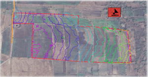
2. Catchment Area Study Using Toposheets and GIS
The next phase includes an in-depth geographical and spatial study.
2.1 Toposheet Analysis
- Data: Survey of India toposheets (1:50,000 or 1:25,000 scale).
- Output: Identification of terrain features, slopes, drainage paths, and watershed boundaries.
2.2 GIS-Based Catchment Delineation
- Software Used: ArcGIS, QGIS, HEC-GeoHMS.
- Steps:
- Generate Digital Elevation Model (DEM).
- Run flow accumulation and direction tools to delineate catchments.
- Overlay land use/land cover (LULC) data to evaluate infiltration capacity.
- Purpose: Accurate modelling of runoff, water accumulation points, and flow direction from upstream to downstream areas.
3. Preparation of Detailed Project Report (DPR)
A well-documented DPR consolidates all findings and design recommendations.
3.1 Hydrological and Hydraulic Design
- Hydrological Modelling:
- Use Rational Method or SCS-CN method for runoff estimation.
- CN value determined by soil type, LULC, and antecedent moisture conditions.
- Hydraulic Design:
- Design of stormwater drains, culverts, detention basins using Manning’s Equation: Q=1nAR2/3S1/2Q = \frac{1}{n} A R^{2/3} S^{1/2}Q=n1AR2/3S1/2. Where Q = discharge, A = area, R = hydraulic radius, S = slope, n = roughness coefficient.
4. General Description of Climatology
4.1 Climate and Rainy Seasons
- The zone lies within a tropical monsoon climate zone.
- Main rainfall from June to September (Southwest Monsoon).
- Annual average rainfall: 1,200 mm – 1,800 mm depending on location.
4.2 Rainfall Map
- A GIS-generated isohyetal map illustrates the spatial distribution of rainfall.
- Identifies zones of high rainfall concentration and potential flood-prone areas.
5. Highest Flood Level (HFL) of Site
- Methodology:
- Obtain past flood records from Central Water Commission (CWC), local municipal records.
- Analyze flood marks, river gauge levels, and topographical elevations.
- Finding: HFL is determined to be X.XX m above mean sea level (MSL), essential for fixing plinth levels of structures and road embankments.
6. Design Intensity of Rainfall
- Input: Based on the 30-year rainfall analysis.
- Application: Used in runoff calculation and sizing of stormwater infrastructure.
7. Flood Risk Analysis
- Approach:
- Use HEC-RAS for floodplain modelling.
- Simulate flood levels based on inflow from upstream catchments.
- Factor in blocked or undersized drains, urbanization impacts.
- Results:
- Identified low-lying areas susceptible to flooding.
- Flood zone mapping with 100-year return period.
8. Historical Data and Extreme Events
- Notable episodes:
- Year 1996: Flash floods due to cloudburst.
- Year 2005: Urban flooding after 350 mm rainfall in 24 hours.
- Hurricane/Cyclone Data: Region not cyclone-prone, but receives heavy spillover rains from Bay of Bengal systems.
9. Natural Water Streams Crossing the Site
- Survey Findings:
- One seasonal nullah crosses the northeast boundary.
- Stream has a historical tendency to overflow.
- Recommendation:
- Relocate the stream through an engineered open channel on the periphery.
- Provide gabion lining and check-dams to slow velocity and prevent erosion.
10. Analysis of Potential Flood Sources
- Nearby Rivers: River A (5 km west), River B (7 km south).
- Risk:
- Backflow risk from River A during monsoon if drain outfalls are not equipped with flap gates.
- Lake X upstream has no regulated discharge mechanism.
- Suggested Actions:
- Model peak discharges from external sources.
- Design embankments or detention ponds to manage inflow.
11. Drainage Recommendations
11.1 Drainage Design Principles
- Use gravity-based flow wherever possible.
- Minimum velocity: 0.6 m/s to avoid sedimentation.
- Pipe/drain size determined from peak discharge.
11.2 Outlet Points
- Discharge to natural drain on the eastern boundary.
- Install silt traps and oil-water separators before outlet.
- Provide emergency overflow channels in case of blockage.
12. Design Drawings
All design drawings must cover the following:
- Catchment area delineation maps.
- Rainfall isohyetal map.
- Flood zone and HFL map.
- Drainage layout plan showing primary and secondary drains.
- Sections of channels and culverts.
- Hydraulic grade line profiles.
- Location of natural streams and proposed diversions.
- Placement of silt traps, detention ponds, and outfalls.
The Hydrology Study Report integrates climatological data, hydrological modelling, flood risk assessments, and hydraulic design principles to provide a comprehensive framework for water management in any proposed development area. With careful consideration of rainfall patterns, flood history, and catchment behavior, the report ensures long-term sustainability, safety, and regulatory compliance.
This report should be included as part of the Detailed Project Report (DPR) and submitted to relevant authorities for review and approval before any construction activities commence.
Hydrology study for Irrigation planning and management | Hydrology study for Soil moisture analysis | Hydrology study for Drought prediction and mitigation | Hydrology study for Water Resources Management | Hydrology study for Surface and groundwater assessment | Hydrology study for Watershed management | Hydrology study for Aquifer recharge and sustainability | Hydrology study for Civil Engineering & Infrastructure | Hydrology study for Design of dams, bridges, canals, and culverts | Hydrology study for Urban drainage and flood protection systems | Hydrology study for Environmental Management | Hydrology study for Wetland conservation | Hydrology study for River and stream ecosystem protection | Hydrology study for Pollution transport modeling | Hydrology study for Urban Planning & Development | Hydrology study for Stormwater management | Hydrology study for Urban flood modeling | Hydrology study for Water supply and sewage design | Hydrology study for Disaster Management | Hydrology study for Flood forecasting and early warning systems | Hydrology study for Drought monitoring | Hydrology study for Hydropower and Energy | Hydrology study for Site selection and feasibility studies for hydropower | Hydrology study for Flow rate and water availability analysis | Hydrology study for Mining and Geotechnical Engineering | Hydrology study for Dewatering studies | Hydrology study for Mine water management | Hydrology study for Climate Change and Sustainability | Hydrology study for Impact assessment on hydrological cycles | Hydrology study for Modeling changes in precipitation and runoff patterns | Hydrology study for Navigation and Inland Water Transport | Hydrology study for River flow regulation | Hydrology study for Channel depth monitoring